HISTORIX 2009 Pakistan Map Poster - 18x24 and 50 similar items


Free Shipping
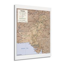
HISTORIX 2009 Pakistan Map Poster - 18x24 Inch Map of Pakistan - Islamic Republi
£30.08 GBP - £41.36 GBP
View full item details »

Shipping options
Seller handling time is 1 business day Details
No shipping price specified to GB
Ships from
United States

Return policy
Full refund available for DOAs
Details
Purchase protection
Payment options
PayPal accepted
PayPal Credit accepted
Venmo accepted
PayPal, MasterCard, Visa, Discover, and American Express accepted
Maestro accepted
Amazon Pay accepted
Nuvei accepted
View full item details »
Shipping options
Seller handling time is 1 business day Details
No shipping price specified to GB
Ships from
United States
Return policy
Full refund available for DOAs
Details
Purchase protection
Payment options
PayPal accepted
PayPal Credit accepted
Venmo accepted
PayPal, MasterCard, Visa, Discover, and American Express accepted
Maestro accepted
Amazon Pay accepted
Nuvei accepted
Item traits
| Category: | |
|---|---|
| Quantity Available: |
16 in stock |
| Condition: |
New |
| UPC: |
737214977216 |
| Item Name: |
2009 Pakistan Poster Print |
| Item Type Keyword: |
prints |
| Unspsc Code: |
60121013 |
| sizes: |
Listing details
| Seller policies: | |
|---|---|
| Shipping discount: |
Seller pays shipping for this item. |
| Posted for sale: |
May 1 |
| Item number: |
1743606696 |
Item description
Produced by the Central Intelligence Agency, this depiction of Pakistan shows the nation in a period of cultural, political, and economic transformation. CIA maps contain the most up-to-date geopolitical boundaries and borders and are used by political and military leaders to develop and implement foreign policy and strategy. Following the conclusion of the Kargil War in 1999, a period of enlightenment swept the nation and included economic reforms and more liberal social policies. CIA maps have been produced and archived since 1941 and are known for their minimal aesthetic and uniform appearance.
Pakistan has a rich history, and its location between India, China, Afghanistan, and Iran has shaped its culture for centuries. It is also the site of several ancient civilizations and archaeologically significant sites. As the fifth most populous country in the world, Pakistan gained independence from colonel British rule in 1947 and established a government based on Islamic rule in 1956. A nine-month civil war in 1971 resulted in the establishment of Bangladesh in eastern Pakistan. This map was published following the installation of a civilian government which would go on to create a parliamentary system with periodic elections.
CIA maps are regarded for their accuracy and are updated frequently as geopolitical and international boundaries shift and evolve. By the early portion of the twenty-first century, Pakistan had seen significant transformation since its independence and maintains a distinct place in the Islamic world culturally, religiously, and politically. This is an authentic piece of global cartographical history.
Our museum quality giclee print comes printed with archival ink on premium heavyweight matte paper. Shipped in a sturdy cardboard tube your print will arrive ready to be framed. This eye-catching vintage map reproduction print makes the perfect gift for anyone that loves history and imagery.
|
Why are we showing these items?
Booth
Historic Prints |

|


-
Refine your browsing experience
We can show you more items that are exactly like the original item, or we can show you items that are similar in spirit. By default we show you a mix.

This item has been added to your cart
 HISTORIX 2009 Pakistan Map Poster - 18x24 Inch Map of Pakistan - Islamic Republi added to cart.
16 available in stock
HISTORIX 2009 Pakistan Map Poster - 18x24 Inch Map of Pakistan - Islamic Republi added to cart.
16 available in stock
View Cart or continue shopping.
 Please wait while we finish adding this item to your cart.
Get an item reminder
We'll email you a link to your item now and follow up with a single reminder (if you'd like one). That's it! No spam, no hassle.
Already have an account?
Log in and add this item to your wish list.