HISTORIX 1862 Washington DC Vintage Map - 20x24 Inch Historic Washington DC Map
Ships from
United States

Shipping options
Seller handling time is 1 business day Details
This reflects the seller's handling time and may not include time spent in transit.
If you have questions about shipping, please contact the seller.
No shipping price specified to GB
Ships from
United States
Return policy
Full refund available for DOAs
Details
- We guarantee our products and offer full refunds or exchange for defective items or items not as-described.
- Buyer must contact us within 30 days after receipt of shipment.
- The item must be received in the same condition as shipped.
- Items must be returned with all original packaging and accessories.
- Items must not be abused, modified or damaged by accident.
- A 20% restocking fee will be charged for returns
- Buyer is responsible for all return shipping and handling fees.
- Restocking and return shipping fees do not apply when item is returned as defective or because incorrect product was delivered.
Payment options
PayPal accepted
PayPal Credit accepted
Venmo accepted
PayPal, MasterCard, Visa, Discover, and American Express accepted
Maestro accepted
Amazon Pay accepted
Nuvei accepted
Item traits
| Category: |
Kitchen Scales
|
| Quantity Available: |
16 in stock
|
| Condition: |
New
|
| ASIN: |
B088BKHVGX
|
| Item Name: |
HISTORIX 1862 Map Washington D.C. Civil War Fortifications
|
| manufacturer: |
Historix
|
| Item Type Keyword: |
wall-maps
|
| Product Site Launch Date: |
2020-05-08T03:29:27.189Z
|
| Brand: |
HISTORIX
|
| Unspsc Code: |
52140000
|
| sizes: |
View details
20x24 Inch (8 in stock)
24x30 Inch (8 in stock)
|
Listing details
|
Seller policies:
|
View seller policies
|
|
Shipping discount:
|
Seller pays shipping for this item.
|
|
Posted for sale:
|
April 29
|
|
Item number:
|
1743200299
|
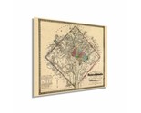
Published just one year after the outbreak of the Civil War, this topographical and fortification map of Washington DC provides a unique glimpse into the city at one of the most tumultuous times in American History. The Nation’s capital was the most vulnerable and strategically important city during the conflict as it was the geographic dividing line between the North and South. Because of this, the city experienced a massive boom in population as fortifications and defensive forces became increasingly important.
This significant growth was spurred by the rapid expansion of the federal government, which found itself scrambling to provide war funds and armaments to deter an invasion from Confederate forces. Only one invasion attempt occurred in 1864 and marked the first time since 1812 that a sitting US President had been fired on. The battle ended quickly, and confederate forces retreated south.
The inauguration of President Abraham Lincoln happened one year earlier, and the amount of information historians and genealogists can glean from this artifact is immense. Landowner names and rural schools are depicted as well as the numerous Union Forts that had been constructed.
Produced by prolific American cartographer GH Colton this unique depiction of the iconic city immediately transports the viewer back in time. Colton produced maps on heavy steel engraving plates, instead of cheaper wax engravings, and they were considered the highest quality. His company was the leading publisher of maps from 1830 to 1890, and these esteemed prints are genuine pieces of cartographical history.
Our museum quality print comes printed with archival ink on premium heavyweight matte paper. Shipped in a sturdy cardboard tube your print will arrive ready to be framed. This eye-catching vintage map reproduction print makes the perfect gift for anyone that loves history and imagery.